The East Cemetery

The East Cemetery

Marble statue of a Kore (detail)

The East Cemetery

The East Cemetery, which extended out beyond the East Gate, appears to have been organized along either side of a road that led to the shores of the Mazoma lagoon. This cemetery remains very little explored, even though Alexandros Filadelfeus carried out the first excavations here in 1913. At the site of Nikolara, a chamber mausoleum with a rectangular semi-underground burial chamber has been excavated. In the middle of its north side, an interior three-step staircase led to a paved floor one meter lower. Around the chamber’s perimeter were four stone sarcophagi inside brick constructions and three chests, also of brick, containing cinerary urns, from which only one glass vase dating to the 1st century AD was found in situ. Cinerary urns had been installed in the walls, and on the floor a pointed-toe cinerary amphora and grave stele with the inscription Με(μία) / Φίλα / ἐτῶν λ΄ / Φουλβεινία / Πανθήρα / ἐτῶν ιδ΄ / χαίρετε were found. The inscription refers to two deceased females who according to their Roman clan names (Memmia, Fulvinia) possessed Roman citizenship. The monument is dated to the late 2nd-early 3rd century AD.

Individual graves were investigated in the same region, brick cist tombs for the most part which yielded rich grave goods (lamps, glass vases, silver and bronze rings) and grave stelae. Marble sarcophagi with relief decoration and stone sarcophagi of the Assos type were also found.

The tomb stele of sailor Ferox

Map

EARLY CHRISTIAN NICOPOLIS

EARLY CHRISTIAN NICOPOLIS

Virtual plan of the Early Christian Nicopolis

EARLY CHRISTIAN NICOPOLIS

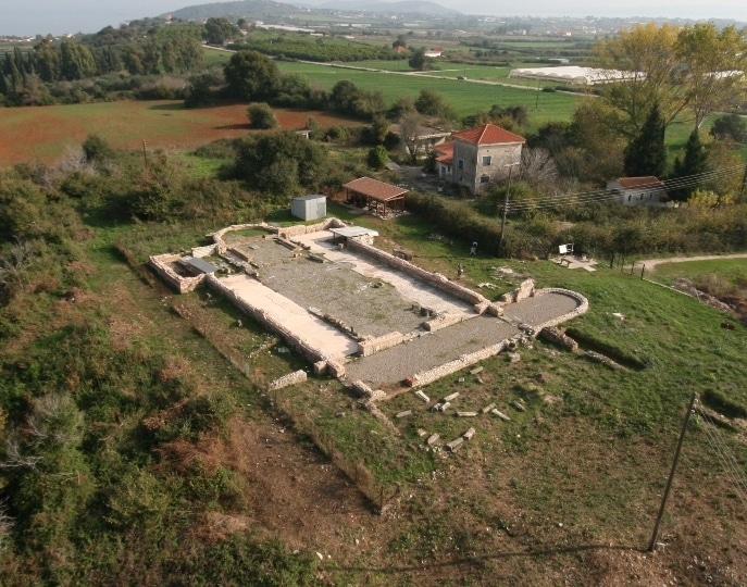
The predominance of Christianity and the consequences of the barbarian invasions which began in the 3rd century AD and continued during ensuing centuries also exerted a direct influence on Nicopolis’s civic landscape.  The houses of worship for the new religion, which were the center not only of religious but of social and political life as well, took up a significant part of the urban area with their size and bulk.

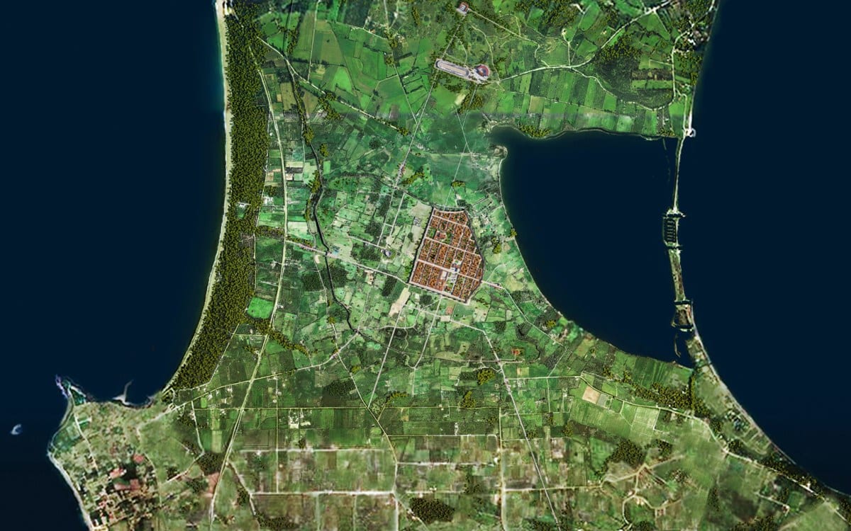
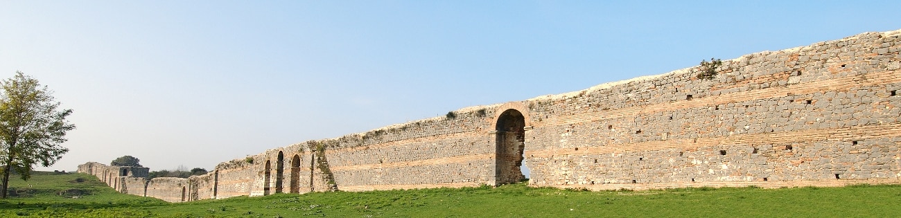
The Herulian invasion in the mid-3rd century AD demonstrated the weaknesses of the Augustan fortification wall. A reassessment of the functionality of the fortifications following the city’s occupation by the Vandals in 474 led to a reduction in the wall’s perimeter and reorganization of the urban area. The Early Christian city was limited to the northeast sector of the original (Roman) city plan, occupying an area of about 274 stremmata (27.4 hectares), i.e. one-fifth of the area enclosed by the Roman walls.

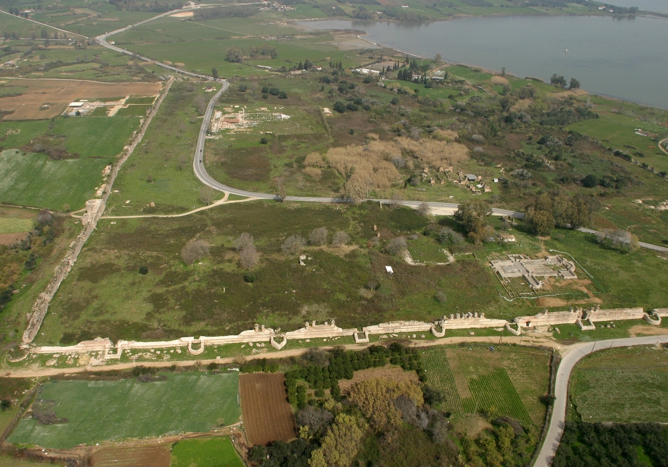
The choice of location within which the Early Christian city was confined appears to have been determined by specific reasons. The site’s geographic advantages probably took precedence over preserving the public buildings of the Roman age, which fell into disuse when Christianity prevailed. For example, the area where the center of the Roman city (the Forum) with important buildings like the Odeum had been located remained outside the new fortifications. The section chosen to create the new city was near the fish-breeding Ambracian Gulf, the primary source of wealth for Nicopolis and a communication route to inland Epirus. Furthermore, access by road to the city’s large port on the Bay of Vathi was relatively easy via the southeast gate of the Roman fortifications. The harbor settlement apparently flourished during Early Christian times, as shown by the remains of a magnificent basilica at the site of Agios Minas (Menas) on the east side of the bay.

The source of water which flowed on the slope below the house (domus) of the ekdikos Georgios was certainly an advantage in the choice of site. An additional reason was the fact that the terrain in this part of the city, which presents a gentle N-S decline, facilitated the natural flow of waste into the sewers. This waste must have ended in the lagoon of Mazoma, whose coastline was many meters further west, as geophysical investigations in the 1990s showed. Finally, it is possible that the insignificant number of ancient religious buildings in this area of the city in relation to others may have played a role in the choice of site.

The precinct in the sacred grove of the suburb, as in the original city plan, remained outside the fortifications. With the abolition of athletic games throughout the empire, the monuments of the suburb were abandoned. The new walls, the buildings for Christian worship, and the so-called “Nymphaeum” are the main visible remains of the Early Christian city.

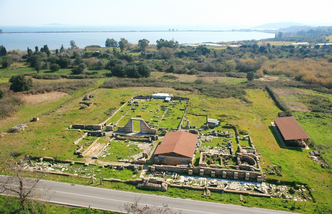
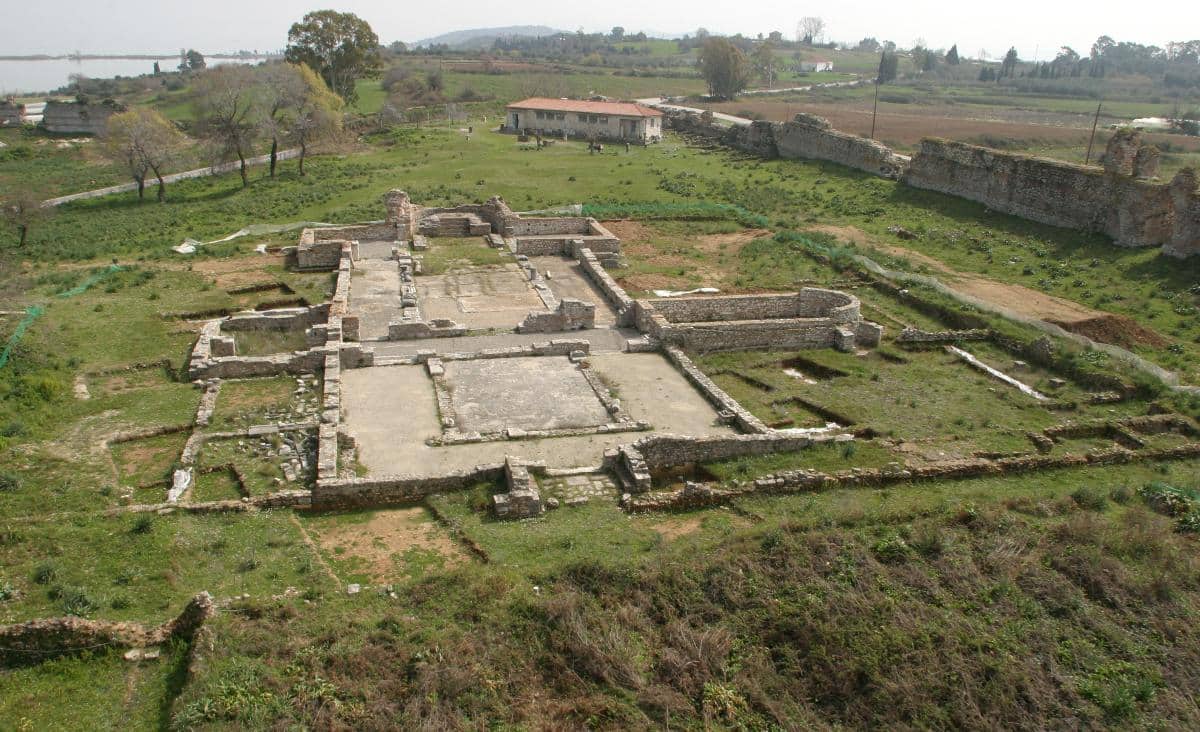
The evidence at our disposal about the urban fabric and private residences of Early Christian Nicopolis is limited. Generally speaking, it appears that the orthogonal Roman town planning system was retained, though it probably became denser. The plans of two of the four basilicas found inside the wall, Basilica A (of Dometius) and Basilica B (of Alkison) were adapted to the ancient Roman plan, since their main entrances on the west were on N-S roads (cardines) laid out by the Romans. Two of the three identified gates also coincided with the original road axis. The so-called “Beautiful Gate” in the south wall lay on the axis of the cardo which passed by west of Basilica A. However, the axis of the main gate in the west wall was not on the axis of the road laid out by the Romans. It is possible that for reasons having to do with adaptation to the terrain, the Roman road had deviated at this point from the strictly geometric plan. The east gate of the Roman fortification wall, which led to the coast at the lagoon of Mazoma, was rebuilt and continued in use during Early Christian times.

Virtual plan of the Early Christian Nicopolis

Map

FORTIFICATIONS

THE FORTIFICATIONS

Aerial photo of the walls and Basilicas A and B

THE FORTIFICATIONS

The Early Christian walls of Nicopolis, one of the most important assemblages of fortification architecture in the southern Balkans, are impressive for their size and preserved height of up to twelve meters. They were built by incorporating part of the Roman walls and taking into consideration the Roman urban fabric. The walls, which have a perimeter of about 2072 meters, are trapezoidal in plan and reinforced by towers. The south wall was erected along the south side of the main road that crossed the Roman city from east to west (decumanus maximus), proving that the road continued in use during Early Christian times. The same tactic appears to have been followed on the west wall, which apparently ran along a north-south road (cardo). To the north and east, the new fortifications used the Roman wall, whose height was augmented.

There were a total of 12 towers along the south wall, set at regular intervals of 33 meters: rectangular, semicircular, and polygonal towers alternated with one another in the same order; there was a round tower at the southwest corner and a polygonal one at the southeast corner. In the small oblique part of the south wall that continued until it met the Roman wall on the east side, there was a series of two semicircular towers, a square tower, and a polygonal tower. A different organizational system was followed for the west wall, which has a total of 16 towers: 11 rectangular ones in a row, 2 circular ones at the north and south corners, 2 horseshoe-shaped ones flanking the main west gate, and a circular one on the north side of a postern 184 meters north of the west gate. The distance between towers ranges between 26 and 40 meters.

The polygonal tower in the south wall

Two or three courses of cornerstones at the base of the wall formed a podium-euthynteria atop which rose the superstructure. The doorways had monolithic lintels surmounted by a single or double relieving arch with brick drum. The staircases on the west side, which had a rampart-walk, are preserved in better condition. The core of the wall’s stone construction consisted of mortar, rubble, stone and marble fragments from Roman monuments, even statue fragments, in addition to fragmentary and intact bricks from the Augustan wall. The many spolia prove that important public structures of the Roman period were abandoned in Early Christian times.

The south and west walls clearly belong to separate building phases. The rubblework faces of the west wall are more carefully-constructed, with decorative brickwork in places. If as some scholars maintain we accept the cornices with relief decoration of Early Christian times as a terminus post quem, then the west wall postdated the south.

On the east wall (unexcavated to date), the Augustan wall was used, having been repaired and raised. A number of rectangular towers have been identified, one of which survives to a great height and is similar in construction to the towers along the west wall.

The north wall of the fortifications, in which the repaired Roman wall was also reused, remains largely unexcavated as well. In its western section, at the point where the modern motorway passes and as far as the north tower of west wall, extensive rebuilding is observed in which spolia from Roman buildings were employed. One can see fluted and unfluted column drums, columns, and cornerstones, interspersed with the rubble and brick of the Roman wall. The construction suggests a state of emergency, and should be associated with the Herulian invasion of the mid-3rd century. East of the road one finds the continuation of the Roman wall and a large triangular bastion dating to Early Christian times. Due to the steeply-sloping ground on this side of the wall, it is considered that there must have been a protective moat that would have been linked with the lagoon of Mazoma.

The dating of the Early Christian walls is highly problematic. Earlier opinion had connected them with Justinian (6th c.), relying on the historian Procopius, who in recounting the fortifications with which the emperor had strengthened many cities in the empire in On buildings (4.1.37.1) mentions that Justinian also renewed Nicopolis (ανενεώσατο δε την Νικόπολιν). In any case, contemporary research dates the construction of the fortifications to around the second half of the 5th century, to the reign of the Emperor Zenon (474-491) or more likely, Anastasius (491-518). Excavation evidence to support either of these views is still lacking.

The West Gate as reconstructed

The Early Christian walls of Nicopolis, one of the most important assemblages of fortification architecture in the southern Balkans, are impressive for their size and preserved height of up to twelve meters.

View of the city walls

Map

BASILICAS

BASILICAS

Virtual reconstruction of Basilica A

BASILICAS

There have been six basilicas found to date in Early Christian Nicopolis, which are known in the bibliography on the basis of the order in which they were discovered (Basilicas A – F). They are inside the walls (intra muros), with the exception of mortuary Basilica D, which was near the southeast gate of the Roman fortifications, and Basilica E, which was near the Bay of Vathi. However, given that a large section of the city has not been excavated yet, the above basilicas probably do not represent all of the city’s churches. This hypothesis is supported by the fact that Nicopolis was the seat of the provincial governor of Old Epirus and the archbishop of the same province, with jurisdiction over all the local bishops.

Aerial photo of the walls and Basilicas A and B

Map

Basilica A (of the Bishop Dometius)

Basilica A (of the Bishop Dometius)

Aerial photo of Basilica A

Basilica A (of the Bishop Dometius)

Basilica A is in the southern part of Early Christian Nicopolis, southeast of the intersection of two important roads: the main E-W avenue, the decumanus maximus of the Roman urban plan, and a road perpendicular to it (cardo) which ended at the south gate of the Early Christian wall known as the “Beautiful Gate” (Oraia Pyli). It is known as the basilica of the Bishop Dometius (Doumetios) after two bishops of this name who according to metrical inscriptions on their mosaic floors were the founder and dedicator of part of its mosaics, respectively. The Latin name of the bishop, Dometius, is mentioned in the dactylic hexameter inscriptions as Doumetios. As attested by an inscription on the mosaic floor of the atrium’s western portico, the church was dedicated to Saint Demetrius.

The church is a three-aisled, timber-roofed basilica with transept, atrium, and annexes. The main entrance was on the west, with a monumental propylon probably surmounted by a pediment. The main entrance led to the atrium (ύπαιθρον), a type of vestibule for the faithful to gather. It consisted of a central open-air paved area and three surrounding porticos, decorated with mosaic floors. The five-line founder’s inscription on the floor of the west portico mentions both of the bishops Dometius as well as Saint Demetrius.

The five-lines founder's inscription on the mosaic floor

Two doors led from the south and north to the narthex, with one of the loveliest mosaic floors in Nicopolis on which were depicted an impressive variety of plants and animals in 88 intertwining circles. The narthex communicated with the annexes on both the north and south; the south annex is interpreted as a diakonikon, a place to deposit offerings by the faithful. Its floor was covered by an exquisite mosaic.

The nave was divided into three aisles, with two colonnades. A second colonnade above the first supported the basilica’s gallery. Stone closure slabs along the outer side of the stylobates isolated the wider and slightly-elevated central aisle, which was paved in a mosaic floor. The side aisles were paved in colorful opus sectile.

A single gabled roof covered the central aisle and sanctuary, while the side aisles, which were lower, had independent pitched roofs. North and south of the sanctuary were the parabemata which probably served liturgical needs such as the storage of sacred utensils.

In addition to the church’s exquisite mosaic floors—among the best-known and most important in the Greek region—it also had rich sculptural decoration: bifacial closure slabs decorated with Christograms and with the motif of the lambs on either side of the cross (unique for Nicopolis).

Like ancient Greek temples and sanctuaries, Christian basilicas too had enclosure walls, the herkos (ἕρκος) according to Eusebius of Caesarea (4th c.) and the peribolaion (περιβόλαιον) according to Markos Diakonos (5th c.).

The erection of the basilica by the first Dometius is dated to about the mid-6th century, while the completion of the church’s mosaics by his successor (also Dometius) is dated to the third quarter of the same century.

The mosaic floor of the south pastophorion

The erection of the basilica by the first Dometius is dated to about the mid-6th century, while the completion of the church’s mosaics by his successor (also Dometius) is dated to the third quarter of the same century.

Virtual reconstruction of Basilica A

Virtual Tour

Map

Basilica B (of the Bishop Alkison)

Basilica B (of the Bishop Alkison)

Aerial photo of Basilica B

Basilica B (of the Bishop Alkison)

Basilica B, also known as the basilica of the Bishop Alkison, lies in the northwest part of Early Christian Nicopolis about fifty meters east of its western wall. It belonged to a larger religious complex extending over a total area of about 5900 square meters, which included the splendid basilica, a partially-excavated baptistery, and various other annexes. Due to its large size and costly construction, it is believed to have been the cathedral church of Nicopolis and the seat of its archbishop (metropolitan). The church was a five-aisled timber-roofed basilica with a tripartite transept which did not project beyond the side aisles. We still do not know to which saint this splendid church was dedicated

A road with N-S direction (cardo) of the Roman city passed by west of the church. Along the west side of the church and its annexes, the road was roofed by a sort of portico which had two monumental main entrances on the north and south with triple openings (tribela).

The atrium porticos had mosaic floors decorated in large rotae siricae in which primarily geometric motifs were recorded. In the east part of the atrium and in contact with the narthex wall there are remains of a rectangular built reservoir.

East of the atrium was the narthex, whose floor had a mosaic decoration of geometric designs. The central doorway, the Royal Gate, which had a marble frame with convex-concave (cyma recta) moldings, was restored by Anastasios Orlandos in 1964. Four porticos, each composed of twelve monolithic columns, created the five aisles of the nave, which were of different widths.

The free-standing altar table occupied the central position in the sanctuary. It was covered by a marble ciborium resting on four columns. In the sanctuary apse there was a built podium with five semicircular steps atop which the bishop’s throne was placed. Priests sat on the “lower range” of two-step benches, the subsellia (συμψέλλια) on either side of the podium. Behind the podium was the ambulatory (κύκλιον). Excavation outside the apse located the continuation of this Roman building and part of a mosaic floor with a bucolic scene of very high artistic quality.

At about the center of the south side of the central aisle, there are preserved remains of the ambo, whose floor was formed by with a cylindrical marble pedestal-base. The base made of Pentelic marble and with a relief scene of an Amazonomachy around its circumference, had once supported a colossal male portrait statue of the 2nd century AD. During the incorporation of the pedestal base into the ambo, part of the representation was carved off and replaced with mosaic decoration, from which two busts of figures in circular medallions are preserved.

Pedestal base of the ambo; the mosaic that covered the ancient relief

Not far north of the church, an oblong structure was found. This building, which has been partially excavated, is identified as the Baptistery. The annexes on the southwest side of the church were configured around the circumference of a small paved atrium containing two wells. On one of these, a cylindrical altar was used as a well-head after its center was carved out. The altar was dedicated to Asclepius according to the inscription ASKLEPIOU (ΑCΚΛΗΠΙΟΥ) preserved on its surface. The annexes are rectangular or apsidal in plan, and their floors are paved with inlaid marble or mosaics. The discovery of two staircases attests to the presence of an upper floor. The floor of room C, whose use remains unknown, was decorated with a splendid mosaic similar to that in the basilica’s narthex. A fragmentarily-preserved inscription just below the entrance threshold mentions the Bishop Alkison as founder. The latter was a well-known Bishop of Nicopolis during the reign of the Emperor Anastasius (491-519 AD), and the erection of the southwest annexes is attributed to him.

The erection of Basilica B is dated to the middle or second half of the 5th century. Generally speaking, three building phases are distinguishable for interventions following the erection of the church. The first was associated with the Bishop Alkison, and is dated to the late 5th-early 6th century and in any event prior to 516, the year of his death. The second repair phase is placed in the mid-6th century and associated with the Bishop Dometius (Doumetios) (probably Dometius II). The third phase is dated to the late 6th-early 7th century, and involved interventions to the atrium, the annexes, and the portico west of the basilica.

The altar of Asclepius

Basilica B, also known as the basilica of the Bishop Alkison, is believed to have been the cathedral church of Nicopolis and the seat of its archbishop (metropolitan) due to its large size and costly construction.

Marble coffer with rosette

Map

Basilica D

Basilica D

Basilica D

Basilica D lay atop the low hill of Karaouli with a view overlooking the Ambracian Gulf, outside the walls of Early Christian Nicopolis but within and near the Roman walls and their southeast gate. It was found in the early 1950s during excavations by the Hellenic Telecommunications Organization (OTE) when a wireless antenna was being installed. Its location outside the Christian city and the burials found inside it led to the conclusion that it must have been associated with one of the Christian cemeteries.

Basilica D was three-aisled and timber-roofed, with a projecting tripartite transept, narthex with annexes, and atrium. The expansion of the north and west walls of the atrium beyond its northwest corner attests to the existence of a portico which apparently ensured the main access to the church from the road.

Two doors at the eastern end of the north and south porticos of the atrium led to the narthex, a small part of whose mosaic floor survives. In the center of the floor among geometric designs, a wreath with colorful flowers and fruits held up by a winding band was depicted. This was an extremely common decorative motif in sculpture, but it was rare in the decoration of mosaic floors, an element indicative of the fine and original artistic quality of works by the Nicopolis mosaic workshop.

The Narthex of Basilica D

A narrow opening in the south wall of the narthex led to a small apartment, probably the diakonikon with an apse on its south side, and a mosaic floor. Three doors in the east wall of the narthex (the widest of which was the central one, the Royal Gate), which originally had luxurious marble frames, led to the nave. Two rows of six Ionic columns which created its three aisles continued into the transept. The floor of the central aisle carried a costly marble inlay (opus sectile) while marble inlaid floors with irregular polychrome tiles (opus segmentatum) are preserved to a notable extent.

The slightly-elevated floor of the bema was decorated with marble inlays similar to that in the central aisle. Only the base of the altar table (Agia Trapeza) is preserved. On either side of it were the built subsellia (συμψέλλια, “lower range”), and further east in the apse was the stepped semicircular stepped pedestal on which the bishop’s throne was placed.

The transept’s two wings communicated with the bema and the side aisles via a double opening on either side of a column (dibelon). In the north apartment, beneath the marble slabs, a marble sarcophagus and built cist tomb containing the bones of at least six individuals was found. Inside the sarcophagus, which was of exceptional artistic quality and came from a sculpture workshop in Constantinople, the dissolved bones of the deceased minus his skull were found. The privileged position of the burial next to the bema in a costly sarcophagus allows us to conclude that the deceased was the martyr to whom the church was dedicated. This hypothesis is supported by the presence of the adjacent tomb, which is interpreted as a burial ad sanctum (a burial beside a martyr), which ensured the salvation of the soul.

The marble sarcophagus of the north apartment

There was also a corresponding small apartment, fenced off by closure slabs, in the southwest section of the south apartment, the “makeshift pastophorion” according to Orlandos. Exploration beneath the floor revealed the presence of two cist graves which contained the bones of at least eighteen persons. The discovery of these tombs reinforces the view that corresponding apartments in Early Christian basilicas were also intended for the burial of officials of the clergy and prominent citizens. The interpretation of the basilica as a mortuary church is further supported by the inscribed fragment of a grave stele dating to the Christian period found in the area of the apse by the first excavators.

The basilica’s sculptures are also notable in their entirety. The imported sculptures must have been specially commissioned for this basilica.

The erection of Basilica D is dated to the first half of the 6th century, primarily on the basis of its architectural sculptures and the mosaic floors in its narthex and diakonikon.

The location of Basilica D outside the Christian city and the burials found inside it, led to the conclusion that it must have been associated with one of the Christian cemeteries.

The cist graves of the south apartment

Map

ARCHAEOLOGICAL MUSEUM

ARCHAEOLOGICAL MUSEUM

THE ARCHAEOLOGICAL MUSEUM OF NICOPOLIS

The building construction of the New Nicopolis Museum was accomplished in 2006. The exhibition work was completed in the summer of 2009, within the framework of the project titled “New Nicopolis Museum: Equipment and Exhibition” funded from the Regional Operational Programme “Epirus” of the 3rd Community Support Framework.

The Museum is dedicated exclusively to the city which was founded in commemoration of the victory of Octavian Augustus at the naval battle of Actium in 31 BC. Based on this, the central theme of the permanent exhibition can be summarized in the phrase: One Battle, One City, One Empire. Octavian’s victory at Actium did not only lead to the founding of Nicopolis; it also had great influence on the shape of the Roman Empire and the course of history.

The Museum displays the crucial position of Nicopolis in the context of the Roman and Byzantine Empire as well as its role between two capitals, Rome and Constantinople. Nicopolis is presented, on the one hand, as the magnificent Roman Nicopolis, the symbol-city of a glorious victory, founded to display the power of the first Roman Emperor, Octavian; a Roman city inhabited by Greeks which soon developed into the imposing center within the framework of the Pax Romana. It is also presented as the Early Christian city, which -after the collapse of the western frontiers, the relocation of the emperor’s capital from the West to the East, and the establishment of Christianity- reassembled and regained its majesty, forming a crucial religious and administrative center, to be finally deserted in the 10th-11th century AD.

The visitors follow a corridor leading to the exhibition halls, where a chronicle leads them through a history of main events which preceded the founding of Nicopolis. In the first hall -entitled The birth and course of the city– the naval battle and the city’s evolution until its gradual decline and desertion are presented consecutively. The second hall –entitled Life in the City- exhibits features of the city which contributed to its evolution as a powerful economical and commercial centre, as well as, aspects of the private life of the inhabitants. Three consecutive corridors display images, maps and various information on the relation of Nicopolis to other large centers of the Roman world, the course of the city after its desertion and destruction until its ruins was discovered by modern travellers, and finally, the excavation research, the extended conservation and substantial enhancement works from the early 20th century until this day.

Το Νέο Μουσείο

Map

Font Resize